Content for TR 22.837 Word version: 19.3.0
0…
4
5…
5.2…
5.3…
5.4…
5.5…
5.6…
5.7…
5.8…
5.9…
5.10…
5.11…
5.12…
5.13…
5.14…
5.15…
5.16…
5.17…
5.18…
5.19…
5.20…
5.21…
5.22…
5.23…
5.24…
5.25…
5.26…
5.27…
5.28…
5.29…
5.30…
5.31…
5.32…
6…
7…
5.13 Use case on sensing for UAV intrusion detection
5.13.1 Description
5.13.2 Pre-conditions
5.13.3 Service Flows
5.13.4 Post-conditions
5.13.5 Existing features partly or fully covering the use case functionality
5.13.6 Potential New Requirements needed to support the use case
...
...
5.13 Use case on sensing for UAV intrusion detection p. 44
5.13.1 Description p. 44
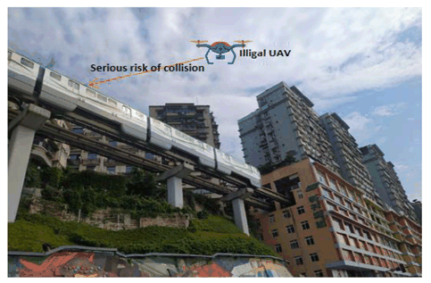
UAV industry is developing quickly around the world with the widely usages in various scenarios such as aerial photography, police force, urban management, agriculture, geology, meteorology, electric power, emergency rescue and disaster relief, etc. Especially for the smart city in future, a large number of UAVs will be used to improve the quality of our daily life including industrial inspection, public security patrol, cargo transportation, live broadcast and so on. However, this also brings big challenges on UAV supervision due to the following reasons:
- Low-altitude UAVs have characteristics as large number, small size, wide flying zone, widely used to execute complex and diverse tasks, which makes UAV supervision very difficult if only using the traditional radar system.
- Non-cooperative UAVs could intrude some no-fly zone (e.g. airport, military base) intentionally or unintentionally which would lead to serious consequences, e.g. exposing private information using the camera, blocking other UAV traffic on the flying route.

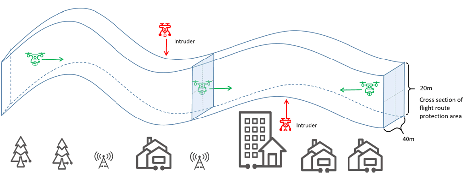
Another example is flight route protection area intrusion detection. Compared to the wide no-fly zone (e.g. airport, military base), the flight route of a UAV is pre-allocated by UTM for given time period with restricted space vertically and horizontally, and it is generally much narrower and longer giving rise to more stringent requirements of positioning of an intruder. Such route in space shall be protected from illegal or uncollaborated UAVs for potential collision and unlawful usage. The characteristics of flight route can be virtualized in Figure 5.13.1-2 as a 3D tunnel with a 40 x 20 meter cross section which shall be monitored or sensed continuously in space and time by the 5G system to detect the presence of unauthorized usage. If illegal UAV is detected over given UAV route, 5GS will trigger intrusion alarm and UTM will take further action to warn the UAV which has been assigned for that route for potential re-routing or other necessary actions.

5.13.2 Pre-conditions p. 45
The UAVs owned by the logistics operator 'YY' will take off and fly. The logistics operator 'YY' requests UTM to manage potential illegal intrusion into the UAV flight routes protection area. The logistics operator 'YY' has provided the information of flight routes protection area to the UTM.
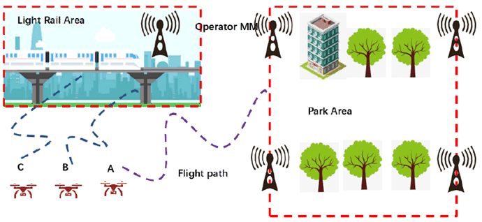
Network operator 'MM' provides 5G sensing service for the park, flight routes protection area of the logistics UAV and the light rail area with its 5G network covering the park, flight routes protection area of the logistics UAV and the light rail track. 'MM' can make use of base stations to sense the airspace within their coverage area and report the sensing information to the USS/UTM as defined in clause 3.1 of TS 23.256.
The Light rail operator 'XX' uses a UTM to management potential UAV illegal intrusion along the light rail tracks. 'XX' has provided its restricted area information to the UTM.
There is a need to hold a ceremony with high security requirement in the park temporarily, turning the park in a restricted area where UAVs are not allowed to enter. The administrator has a subscription for UAV prevention service from the USS/UTM.
The UTM uses '5G Sensing Service' provided by 5G network Operator 'MM' to detect potential UAV illegal intrusion for above scenarios.
The UTM requests that once a UAV is detected that its distance from the border of the restricted area is less than 10m, the 5G system should report the event to the UTM.
The Network operator 'MM' can configure energy consumption sensing mode with different sensing period, e.g. operate sensing one time per 50 seconds, per 10 seconds, per second etc. And in emergency condition, the 5G system can provide continuously sensing service according to the UTM's request.
The light rail works from 5:30 am to 23:00 pm every day.
5.13.3 Service Flows p. 46

The 5G system periodically senses the restricted area whether there are UAVs flying into the restricted area border for both the Park, flight routes protection area of the logistics UAV and the light rail area.
There are three UAVs (A, B, C) flying around the restricted areas.
When UAV A flying near the Park is detected and closely tracked with required accuracy in the sensing area, the 5G system reports the sensing results to the UTM in real time and begins continuously sensing. Then, the UAV A flying into the flight routes protection area of the logistics UAV is detected, and closely tracked with required accuracy in the sensing area, the 5G system reports the sensing results to the UTM in real time and continuously senses.
When UAV B and UAV C flying near the light rail are detected, and closely tracked with required accuracy in the sensing area, the 5G system reports the sensing results to the UTM in real time and continuously senses.
To reduce energy consumption, the 5G system will notify the UTM that the 5G system cannot detect any UAVs illegal flying after a time period which is requested by the UTM. After that, the 5G system stops continuously sensing and begins periodically sensing operation according to the Network Operator's policy.
The USS/UTM could trigger to send warning messages/notices to UAV controller based on analytical results based on the sensing information from the mobile network. Alternatively, the USS/UTM will trigger UAV countermeasures to prevent the UAV from flying in the no-fly area or flight routes protection area of the logistics UAV.
When the ceremony has been finished or the logistics UAV lands, the 5G system would stop sensing operation based on the request from UTM. And when the light rail stops operation between 23:00 pm to 5:00am next morning, the 5G system stops sensing operation to save energy.
5.13.4 Post-conditions p. 46
The mobile network can provide sensing service for UAV intrusion detection with high quality and continuity, to improve the accuracy and efficiency of public safety supervision and management.
USS/UTM interacts with the mobile network for sensing service and perform UAV intrusion detection based on the sensing information exposed by network.
5.13.5 Existing features partly or fully covering the use case functionality p. 47
None.
5.13.6 Potential New Requirements needed to support the use case p. 47
[PR 5.13.6-1]
The 5G system shall be able to provide a sensing service by using RAN to collect 3GPP sensing data.
[PR 5.13.6-2]
The RAN shall be able to sense a target object by obtaining 3GPP sensing data without active involvement of the target object.
[PR 5.13.6-3]
The 5G system shall provide mechanisms for an operator to transport 3GPP sensing data from RAN towards the core network.
[PR 5.13.6-4]
Based on operator's policy and subject to regulatory requirements, the 5G system shall be able to provide a mechanism for a trusted third-party to request the sensing service and based on the request, the base station shall be able to operate sensing periodically or continuously in certain location area for a certain amount of time.
[PR 5.13.6-5]
Based on operator's policy and subject to regulatory requirements, the 5G system shall be able to periodically expose sensing results to a trusted third-party application.
[PR 5.13.6-6]
The 5G system shall provide a mechanism controllable by the operator, according to a business agreement, to report sensing result to a trusted third-party about a target object and multiple target objects when specific conditions are met.
[PR 5.13.6-7]
The 5G system shall be able to support the activation and deactivation of the sensing service according to operator's policy.
[PR 5.13.6-8]
The 5G system shall be able to provide a mechanism for network operator to configure and adjust sensing operation (e.g. authorization, sensing area, sensing operation period and sensing operation time window etc.) based on request from a trusted third-party.
[PR 5.13.6-9]
The 5G system shall be able to provide sensing with following KPIs:
| Scenario | Sensing service area | Confidence level [%] | Accuracy of positioning estimate by sensing (for a target confidence level) | Accuracy of velocity estimate by sensing (for a target confidence level) | Sensing resolution | Max sensing service latency [ms] | Refreshing rate [s] | Missed detection [%] | False alarm [%] | ||||
|---|---|---|---|---|---|---|---|---|---|---|---|---|---|
| Horizontal [m] | Vertical [m] | Horizontal [m/s] | Vertical [m/s] | Range resolution [m] | Velocity resolution (horizontal/ vertical) [m/s x m/s] | ||||||||
| UAV intrusion detection (NOTE 2) | Level 1 | Outdoor | 95 | ≤10 | ≤10 | N/A | N/A | 10 | [5] | [≤1000] | [≤1] | ≤5 | ≤5 |
| Level 2 | Outdoor | 95 | ≤5 | ≤5 | N/A | N/A | 10 | [5] | [≤1000] | [≤1] | ≤5 | ≤5 | |
|
NOTE 1:
The terms in Table 5.13.6-1 are found in clause 3.1.
NOTE 2:
Level 1 and level 2 depend on the size of the restriction area to be sensed.
|
|||||||||||||