Content for TR 22.837 Word version: 19.3.0
0…
4
5…
5.2…
5.3…
5.4…
5.5…
5.6…
5.7…
5.8…
5.9…
5.10…
5.11…
5.12…
5.13…
5.14…
5.15…
5.16…
5.17…
5.18…
5.19…
5.20…
5.21…
5.22…
5.23…
5.24…
5.25…
5.26…
5.27…
5.28…
5.29…
5.30…
5.31…
5.32…
6…
7…
5.12 Use case on Network assisted sensing to avoid UAV collision
5.12.1 Description
5.12.2 Pre-Conditions
5.12.3 Service Flows
5.12.4 Post-Conditions
5.12.5 Existing features partly or fully covering the use case functionality
5.12.6 Potential New Requirements needed to support the use case
...
...
5.12 Use case on Network assisted sensing to avoid UAV collision p. 41
5.12.1 Description p. 41
With the help of current 5G networks, the commercialization of low-altitude UAVs has entered a new stage. UAV can perform surveillance, early warning for many scenarios, and other tasks in low altitude airspace below commercial flights such as delivery. In the logistics industry, UAV delivery is developed very quickly and is estimated to become a nearly 10-billion-euro market. UAV delivery can be widely used in food distribution, retail commodity delivery, postal delivery, provision of medical aids, precision agriculture delivery, industrial delivery, etc.
While the UAV is applied in so many industries, how to avoid collision and effectively manage the UAV traffic are key challenges. In general, the UAV can provide its moving information and surrounding dynamic environment sensed by its own sensors to UTM (Uncrewed Aerial System Traffic Management), then the UTM controls the flight trajectory of the UAV accordingly. But the sensing range of a single UAV is limited and during a UAV flying, the UAV surrounding environment status will not be detected in time which will cause the UAV deviation or collision.
Using the wide coverage of 5G network, a UE on boarding UAV can be a subscriber of the 5G network and connect with UTM via the 5G network.
As shown in Figure 5.12.1-1, through the communication connection between the 5G base station and the UE on boarding UAV, the UE can provide its positioning information and UE ID to 5G network. The 5G network and UTM can corelate the UE positioning information, UE ID with UAV ID. Based on it, on one hand, the 5G RAN nodes can work together to send sensing signal toward specific direction, angle, area to track the flight of the UAV. On the other hand, the UE can collect the reflection signals from its environments and send the 3GPP sensing data associated with the UE ID to 5G network via the communication connection. Some sensing information of the UAV flying environment, e.g. higher building, obstacles and other UAVs nearby, which will impact its safe flying can be collected by UE onboarding a UAV and then reported to 5G core network to be exposed to the UTM. Furthermore, continuous sensing service can be provided during UAV flight.
The UTM is using different inputs like classic radar, via systems currently used in general aviation like FLARM or ADS-B. In this sense, UTM already combines different sources of location information and could further use 5G sensing as additional source for the specific UAV to avoid it deviating from course and collision. When multiple UAVs appear in the same area, the base station also can sense them at the same time.
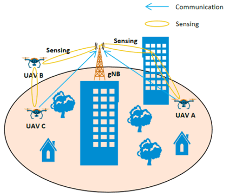
The following service flow gives an example of UAV delivery in retail goods delivery.
5.12.2 Pre-Conditions p. 42
Network Operator 'MM' provides a new 5G service named '5G Sensing Service'.
The UAV City Express 'SS' uses a specific UTM to assist its retail goods UAV delivery.
This UTM uses '5G Sensing Service' provided by 5G network Operator 'MM' as additional source of information and navigate the UAVs.
Tom has ordered online daily necessities from a supermarket. Tom is living in downtown.
Jerry has also ordered online some food from a supermarket. Jerry is living in countryside.
The supermarket prepares the goods in packages and asks City Express 'SS' to deliver them to Tom and Jerry.
City Express 'SS' dispatches UAV A for Tom, and UAV B for Jerry.
UE A is on board UAV A and UE B is on board UAV B. Both UE A and UE B are subscribed to the 5G network of Operator 'MM'.
Through the communication connections between the 5G RAN and the UE A/ UE B, the UE provides its positioning information and UE ID. The 5G network and UTM corelate the UE positioning information, UE ID with associated UAV ID.
5.12.3 Service Flows p. 42
The UAV A and UAV B are flying to their destinations under the guidance of UTM with the assistance of the '5G Sensing Service' provided by network Operator 'MM'.
Considering that UAV A will fly to downtown, the UTM asks network Operator 'MM''s '5G Sensing Service' to provide sensing service for UAV A, and the required sensing result includes the flying environment along its trajectory, e.g. altitude of the buildings, obstacles and other UAVs nearby.
Considering UAV B will fly to the countryside, the UTM asks network Operator 'MM''s '5G Sensing Service' to provide sensing service for UAV B, and the required sensing result includes the flying environment along its trajectory e.g. obstacles, and other UAVs nearby.
The UTM requests the report period about UAV A and UAV B.
Each base station continuously sends sensing signaling along the UAV A's trajectory, and the UE A on board of the UAV A can send the 3GPP sensing data which it collects for its surrounding environment back to the RAN using the 5G communication connection. Then, the 5G network can obtain a comprehensive UAV A's flying environment sensing result e.g. building position, altitude, other nearby moving objects e.g. other UAV's relative position, altitude, degree of moving angle, moving speed etc. to UTM.
Same sensing operation is also for UAV B.
The 5G network reports the sensing result periodically according to UTM's request.
The UTM adjusts and guides the UAV flying trajectories considering the received sensing result and input from other sources (e.g. FLARM, ADS-B).
Considering UAV A is flying toward downtown, both the flying environment (e.g. many buildings) and wireless environment are complex compared with UAV B and its environment in countryside, the 5G network needs to configure different sensing operation for UAV A and UAV B to guarantee required sensing service quality, for example to operate sensing with shorter period, sensing KPI, and report sensing result with higher refresh rate for UAV A.
5.12.4 Post-Conditions p. 43
The UAV A successfully delivers package to Tom and UAV B successfully delivers package to Jerry and return safely.
5.12.5 Existing features partly or fully covering the use case functionality p. 43
None.
5.12.6 Potential New Requirements needed to support the use case p. 43
[PR 5.12.6-1]
The 5G system shall be able to provide a sensing service to track one specific target object and the environment around the target object with the sensing assistance information provided by the UE on board the specific target object or authorized third-party.
[PR 5.12.6-2]
The base stations shall be able to sense multiple specific target objects and their environments at the same time.
[PR 5.12.6-3]
The 5G system shall be able to provide a mechanism controllable by the operator, according to a business agreement, for a trusted third-party to request the sensing service related with a certain target object or multiple target objects of a certain location area.
[PR 5.12.6-4]
Based on operator policy, the 5G system shall be able to provide a mechanism for a trusted third-party to request per location area different sensing services configuration (e.g. sensing KPI, report refresh rate etc.).
[PR 5.12.6-5]
The 5G system shall be able to report sensing result of the environment around a specific target object to a trusted third-party.
[PR 5.12.6-6]
The 5G system shall be able to provide sensing service with follow KPIs:
| Scenario | Sensing service area | Confidence level [%] | Accuracy of positioning estimate by sensing (for a target confidence level) | Accuracy of velocity estimate by sensing (for a target confidence level) | Sensing resolution | Max sensing service latency [ms] | Refreshing rate [s] | Missed detection [%] | False alarm [%] | |||
|---|---|---|---|---|---|---|---|---|---|---|---|---|
| Horizontal
[m] |
Vertical [m] | Horizontal [m/s] | Vertical [m/s] | Range resolution [m] | Velocity resolution (horizontal/ vertical) [m/s x m/s] | |||||||
| Network assisted sensing to avoid UAV collision | Outdoor | 95 | 1 | 1 | 1
NOTE 2 | 1 NOTE 2 | <1
NOTE 2 | 1 | 500 | 0.5 | N/A | N/A |
|
NOTE 1:
The terms in Table 5.12.6-1 are found in clause 3.1.
NOTE 2:
|
||||||||||||
![]()
![]()
![]()