Content for TR 22.837 Word version: 19.3.0
0…
4
5…
5.2…
5.3…
5.4…
5.5…
5.6…
5.7…
5.8…
5.9…
5.10…
5.11…
5.12…
5.13…
5.14…
5.15…
5.16…
5.17…
5.18…
5.19…
5.20…
5.21…
5.22…
5.23…
5.24…
5.25…
5.26…
5.27…
5.28…
5.29…
5.30…
5.31…
5.32…
6…
7…
5.2 Use case on pedestrian/animal intrusion detection on a highway
5.2.1 Description
5.2.2 Pre-conditions
5.2.3 Service Flows
5.2.4 Post-conditions
5.2.5 Existing features partly or fully covering the use case functionality
5.2.6 Potential New Requirements needed to support the use case
...
...
5.2 Use case on pedestrian/animal intrusion detection on a highway p. 17
5.2.1 Description p. 17
Transportation as a basic and essential industry plays one of the important roles in a human's life. Making transportation smarter can make life more convenient and benefit economic development. Highways are an important part of smart transportation. Due to the strong road safety demand on smart transportation, it is necessary to monitor the road situation so as to make appropriate management of road traffic, give guidance or assistance information to vehicles and/or highway traffic safety administration [2].
For example, major accidents caused by pedestrians or animals crossing highways occur frequently [3] [4]. Currently, the highway supervision systems are mainly based on traditional sensors (e.g. radars, cameras) equipped in the roadside infrastructure, but there are still many problems in road supervision system, e.g. it only has partial coverage along the roadside, and the radar may be dedicated for a single usage which requires deploying different types of transportation radars in the same place to satisfy the respective sense use cases and requirements in the area of interest.
Base stations on the roadside are already used to provide 5G coverage for communication, and the radio signals can also be used to sense the environment for object detection.
The assumption of this use case is the following:
- There is at least 10km long and 33m wide dual three-lane carriageway, which has a central reservation to separate the carriageways, six 3.75m wide lanes and two 3.00m wide shoulders to permit emergency stops [9].
- The size and typical velocity of traffic participant is described in the Table 5.2.1-1.
| Size
(Length x Width x Height) |
Typical velocity | |
|---|---|---|
| Pedestrian
(Adult) | 0.5m x 0.5m x 1.75m | 5km/h [9] |
| Animal
(Sheep/deer) | 1.5m x 0.5m x 1 m | 5km/h [9] |
| Vehicle | 4m x 1.75m x 1.5m | 60km/h - 120km/h |
As described in the Figure 5.2.1-1, when the pedestrian/animal standing at the outermost side of the shoulder starts walking on the traffic lane, it means the highway intrusion happens. The distance that pedestrian/animal move perpendicular to the traffic lane (i.e. y direction in the Figure 5.2.1-1) is more sensitive for road safety, compared to the distance parallel to the traffic lane (i.e. x direction in the Figure 5.2.1-1).
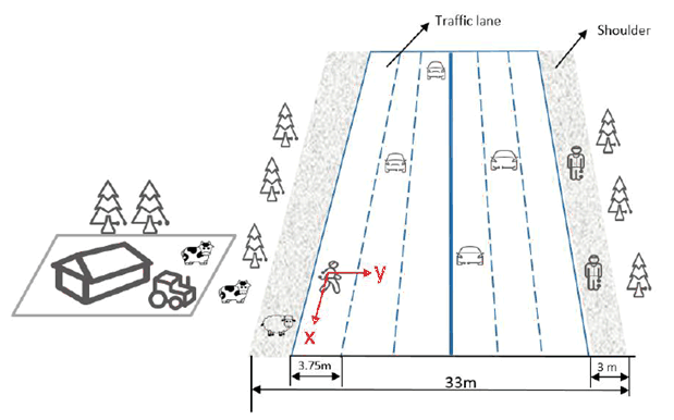
Figure 5.2.1-1: Intrusion detection on a dual three-lane carriageway
(⇒ copy of original 3GPP image)
(⇒ copy of original 3GPP image)
5.2.2 Pre-conditions p. 18
Good partnership and cooperation are established between the road supervision department and Mobile Operator#A in City#B. Requested by the supervision departments for the sensing service, the suitable base stations around/along a highway are selected, which enable Mobile Operator#A to constantly sense the road situation including moving objects (e.g. vehicles and pedestrians). The sensing signal emitted from the base station arrives at vehicles/pedestrians/objects on the road and is bounced (reflected) back to the transmitting base station.
5.2.3 Service Flows p. 18
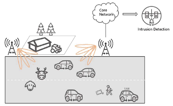
- Fei is a tourist, who is taking a taxi to enjoy the view around the highway in City #B. The base stations around/along the highway constantly sense the road situation. While the taxi is driving on the highway, Fei rolls down the window to take some pictures. Suddenly his mobile phone falls out the window.
- Fei tells the driver to stop and cautiously gets out of the taxi. He crosses the highway and wants to find his mobile phone. Meanwhile, some animals (e.g. sheep and deer) from a farm near the highway approach the road. More and more surrounding vehicles are passing at very high speed. The pedestrian and animals are detected and closely tracked with sufficient accuracy in the sensing area of a base station, and then the 3GPP sensing data is transferred to the core network from the RAN and further processed into the sensing results in the core network.
- The sensing results are exposed by the Mobile Operator #A to the road supervision departments and map provider. The map provider adds the position of the vulnerable pedestrian and animals into the HD dynamic maps and transmits warning messages to the vehicles approaching them. Alternatively, RSUs are connected to the traffic control centre for management and control purposes. RSUs transmit warning messages to the vehicles approaching them. The staff working for supervision departments immediately responds to the emergency, launching temporary traffic management, and rushes to the emergency site to fetch the mobile phone for Fei and drive the animals away from the highway.
- Finally, Fei and animals leaves the highway safely. Potential road accident(s) caused by the pedestrian/animal intrusion are avoided.
5.2.4 Post-conditions p. 19
Thanks to the area-coverage, long-distance sensing capability of the base station (which provides a bird's-eye-view for monitoring the highway environment) the precision and efficiency of highway management and safety supervision is improved. The network-based sensing can provide timely, continuous, accurate, and comprehensive sensing results, which is a reliable basis for highway safety services.
5.2.5 Existing features partly or fully covering the use case functionality p. 19
None.
5.2.6 Potential New Requirements needed to support the use case p. 19
[PR 5.2.6-1]
The 5G system shall be able to support a base station to perform sensing.
[PR 5.2.6-2]
The 5G system shall be able to support means to select suitable base station(s) to perform sensing, e.g. based on the base station's location, sensing capability, and the sensing service information requested by trusted third party application.
[PR 5.2.6-3]
The 5G system shall be able to support means to configure the sensing operation of a base station(e.g. authorization, sensing activation and/or deactivation, sensing duration, sensing accuracy, target sensing location area).
[PR 5.2.6-4]
The 5G system shall be able to support means to enable a base station to transfer 3GPP sensing data to the core network.
[PR 5.2.6-5]
The 5G system shall be able to support means to enable the core network to process 3GPP sensing data for obtaining sensing results.
[PR 5.2.6-6]
Based on operator's policy, the 5G system shall expose a suitable API to a trusted third party to provide the information regarding sensing results.
[PR 5.2.6-7]
The 5G system shall be able to support charging data collection for the sensing services (e.g. considering service type, sensing accuracy, target area, duration) requested by a trusted third-party application.
[PR 5.2.6-8]
Subject to operator's policy, the 5G network may provide secure means for the operator to expose information on sensing service availability (e.g., if sensing service is available and the supported KPIs) in a desired sensing service area location to a trusted third-party.
[PR 5.2.6-9]
The 5G system shall be able to support the following KPIs:
Table 5.2.6-1: Performance requirements of sensing results for pedestrian/animal intrusion detection
| Scenario | Sensing service area | Confidence level [%] | Accuracy of positioning estimate by sensing (for a target confidence level) | Accuracy of velocity estimate by sensing (for a target confidence level) | Sensing resolution | Max sensing service latency[ms] | Refreshing rate [s] | Missed detection [%] | False alarm [%] | |||
|---|---|---|---|---|---|---|---|---|---|---|---|---|
| Horizontal
[m] |
Vertical [m] | Horizontal [m/s] | Vertical [m/s] | Range resolution [m] | Velocity resolution (horizontal/ vertical) [m/s x m/s] | |||||||
| Pedestrian/ animal intrusion detection on a highway | Outdoor (Highway) | 95 | ≤1 | N/A | N/A | N/A | N/A | N/A | ≤5000 | ≤ 0.1 | ≤5 | ≤5 |
|
NOTE:
The terms in Table 5.2.6-1 are found in clause 3.1.
|
||||||||||||
![]()
![]()
![]()