Content for TR 22.837 Word version: 19.3.0
0…
4
5…
5.2…
5.3…
5.4…
5.5…
5.6…
5.7…
5.8…
5.9…
5.10…
5.11…
5.12…
5.13…
5.14…
5.15…
5.16…
5.17…
5.18…
5.19…
5.20…
5.21…
5.22…
5.23…
5.24…
5.25…
5.26…
5.27…
5.28…
5.29…
5.30…
5.31…
5.32…
6…
7…
5.10 Use case on UAV flight trajectory tracing
5.10.1 Description
5.10.2 Pre-conditions
5.10.3 Service Flows
5.10.4 Post-conditions
5.10.5 Existing features partly or fully covering the use case functionality
5.10.6 Potential New Requirements needed to support the use case
...
...
5.10 Use case on UAV flight trajectory tracing p. 35
5.10.1 Description p. 35
With the development of UAV technologies and the increase of demands on rapid logistics, aerial photographing, environmental monitoring and public security, a variety of commercial UAV services gradually become reality.
Normally the commercial UAVs fly based on predetermined flight routes, following regulated positions, heights, speeds, and directions. E.g., a package-delivery UAV flies from the package sender to the package recipient; a task-execution (such as environmental monitoring) UAV flies from the UAV airport to the target area.
On-route flying is important for these commercial UAVs. Their flight routes are optimized and permitted by UAV service operators, UAV management department, or USS (Uncrewed Aerial System Service Supplier)/UTM (Uncrewed Aerial System Traffic Management). Usually, they have the shortest flight distance, avoid no-fly zone, and keep safe distance from obstacles (e.g., building, trees, hills) and other commercial UAVs.
Although a UAV is equipped with sensors to keep itself along the flight route, the external UAV flight trajectory tracing function is still necessary because these sensors sometimes are restricted. E.g., the camera is impacted by light situation; the UAV-borne radar is impacted by rainfall or snowfall, etc. If these events occur, UAV cannot correctly decide its own position, height or speed, and thus cannot follow the traced route.
Although there exist dedicated UAV surveillance equipment and radar, their large-scale deployment has great challenges due to lack of available sites and high installation and maintenance cost.
In comparison, using the 5G system can provide a cost-effective way to trace these UAVs, e.g., 5G network infrastructures with ubiquitous coverage can better trace the flight trajectory of each UAV.
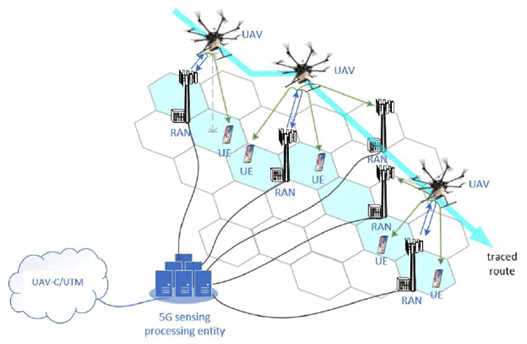
Specifically, 5G RAN entities can rely on radio sensing to obtain the information on UAV position and motion (e.g., distance, angle) and send 3GPP sensing data to a sensing processing entity located in the 5G system.
As shown in Figure 5.10.1-1, the UEs that are connected to the 5G RAN entities can be configured to assist in the sensing operations, which can increase the sensing coverage, provide more positioning reference points, and improve sensing result accuracy and robustness. This improvement is a result of higher density of UEs compared to the base stations, which increases the probability that some UEs are located in positions that have shorter distance away from UAV than 5G RAN entities (e.g., UAV located in the middle of two 5G RAN entities while UE locates under UAV), or some UEs are located in the reflection directions that have larger radar cross section (RCS) than 5G RAN entities considering the UAV RCS variation in different reflection directions.
The 5G sensing processing entity can collect the sensing data from one or multiple network infrastructures.
The 5G network operator can provide the UAV flight trajectory tracing service to a trusted third-party application (e.g., UAV service operator, UAV management department, USS/UTM) as requested.
5.10.2 Pre-conditions p. 36
A UAV operator/UTM provides package delivery service in an area which is covered by 5G network. The UAV operator/UTM subscribes to the UAV flight trajectory tracing service from the 5G network operator.
The UAV operator/UTM provides the 5G network operator the characteristics of the UAV to be sensed, time and space (covering the regulated UAV flight routes and possible off-route locations) of the UAV flight trajectory tracing service.
5.10.3 Service Flows p. 36
When the appointed time starts, 5G network operator activates the UAV flight trajectory tracing function at the appointed space until the appointed time ends.
The UAV operator controls UAV#1 to take off from package delivery source and fly toward package delivery destination along a regulated flight route.
By radio sensing, a set of 5G base stations and UEs detect UAV#1, and then estimate the position and motion related metrics (e.g., distance, angle) as well as the target object is in coverage, resulting in 3GPP sensing data. The 5G RAN and UEs then send the 3GPP sensing data to the 5G sensing processing entity.
In certain cases, during the flying course, based on sensing and location information, if it is detected that UAV#1 has left the coverage of an old base station and entered the coverage of a new base station, the old base station could stop radio sensing and operate in a power saving mode. The new base station starts and keeps on sensing UAV#1 until it is out of coverage. Note that the determination that the UAV#1 has left the coverage of a base station or not could be determined based on the UAV positions and velocities estimated at the 5G sensing processing entity. Therefore, the network could then decide to activate and deactivate sensing in certain base stations based on this information. In other cases, the network could configure a start and stop of sensing operations for a base station based on a specified time period. In some other cases, during the flying course of the UAVs, based on location information, flying trajectory, sensing requirements, network conditions (e.g. network load) etc., if it is detected that the sensing coverage of the current base station monitoring UAV#1 has weakened and/or a new base station is available that can provide better sensing coverage to monitor UAV#1, a proactive sensing handover can be triggered. This would be useful for the sensing service continuity.
The 5G sensing processing entity collects the UAV 3GPP sensing data from one or multiple RANs and UEs, and estimates the positions and velocities, and sends in real time the sensing results (e.g., UAV positions, velocities) to the UAV operator and/or UTM.
Based on the received sensing results, the UAV operator and/or UTM traces the flight trajectory of UAV#1. Once the UAV operator and/or UTM detects an off-route event, it further steers UAV#1.
5.10.4 Post-conditions p. 37
UAV#1 delivers package to the destination along the traced flight route or its off-route behavior is sensed.
5.10.5 Existing features partly or fully covering the use case functionality p. 37
None.
5.10.6 Potential New Requirements needed to support the use case p. 37
[PR 5.10.6-1]
Based on operator policy, request from UTM and sensing configuration (e.g. sensing area), the 5G system shall be able to support RAN entities and UEs in sensing the characteristics of an airborne object of interest (e.g., UAV), including generating 3GPP sensing data related to the object's location and motion metrics (see examples in Table 5.10.6-1).
[PR 5.10.6-2]
The 5G system shall be able to support means to authorize RAN entities and UEs in certain location area generating and reporting 3GPP sensing data (e.g., related to a UAV position, velocity) to a 5G sensing processing entity.
[PR 5.10.6-3]
The 5G system shall be able to support means to process the 3GPP sensing data and expose in real time the sensing results (e.g., related to a UAV position, velocity) from a 5G sensing processing entity to a trusted third-party application.
[PR 5.10.6-4]
The 5G system shall support energy efficient sensing operations.
[PR 5.10.6-5]
Subject to operator's policy, the 5G network may provide secure means for the operator to expose information on sensing service availability (e.g., if sensing service is available and the supported KPIs) in a desired sensing service area location to a trusted third-party.
[PR 5.10.6-6]
The 5G system shall be able to provide the means for supporting sensing service continuity.
[PR 5.10.6-7]
The 5G system shall support sensing services with KPIs as given in Table 5.10.6-1.
| Scenario | Sensing service area | Confidence level [%] | Accuracy of positioning estimate by sensing (for a target confidence level) | Accuracy of velocity estimate by sensing (for a target confidence level) | Sensing resolution | Max sensing service latency[ms] | Refreshing rate [s] | Missed detection [%] | False alarm [%] | |||
|---|---|---|---|---|---|---|---|---|---|---|---|---|
| Horizontal
[m] |
Vertical [m] | Horizontal [m/s] | Vertical [m/s] | Range resolution (horizontal/ vertical) [m x m] | Velocity resolution (horizontal/ vertical) [m/s x m/s] | |||||||
| UAV flight trajectory tracing | Outdoor | N/A | 1-2 | 1-2 | 1-2 | 1-2 | 1m x 1m ~10m x 10m NOTE 2 | 1m/s x 1m/s ~ 10m/s x 10m/s NOTE 3 | 100~1000 NOTE 4 | 1Hz
NOTE 5 | 5 | 5 |
|
NOTE 1:
The terms in Table 5.10.6-1 are found in clause 3.1.
NOTE 2:
To detect the UAV existence (e.g., for intrusion detection), the sensing resolution of distance is 10m [25]. To track the UAV flying (e.g., for collision detection and warning), the sensing resolution of distance is 1m [25].
NOTE 3:
To detect the UAV existence, the sensing resolution of velocity is 10m/s [25]. To track the UAV flying, the sensing resolution of velocity is 1m/s [25].
NOTE 4:
To realize 1m granularity tracking, when the velocity resolution is 1~10m/s, the maximum corresponding sensing service latency is 0.1~1s.
NOTE 5:
Echodyne MESA-DAATM has approximate 1Hz scan rate [40].
|
||||||||||||
![]()
![]()
![]()