Content for TS 23.256 Word version: 19.1.0
1…
4…
4.2…
4.2.3…
4.3…
4.4…
4.5…
5…
5.2.3…
5.2.4…
5.2.5…
5.2.5.3…
5.2.5.4…
5.2.7
5.2.8…
5.2.9…
5.3…
5.4…
5.5…
5.12…
5.13…
5.14…
6…
6.2…
6.3…
6.3.4…
A…
5.14 Support of Network-Based/Assisted DAA
5.14.1 Functional Description
5.14.2 Procedure for UAV Triggered Network-assisted DAA
5.14.3 Procedure for AAM Triggered Network-assisted DAA
5.14.4 Procedure for USS Triggered Network-assisted DAA
5.15 Support of No-Transmit Zones
5.16 Altitude reporting for aerial UEs
5.16.1 General
5.16.2 Instructing aerial UEs to perform altitude reporting
5.16.3 Reporting UE's altitude information
...
...
5.14 Support of Network-Based/Assisted DAA |R19| p. 83
5.14.1 Functional Description p. 83
This clause provides a network-based/assisted DAA mechanism. To enable NWDAA, the following information can be utilised:
- Absolute location of a UAV provided by the LoCation Service;
- Relative Location of UAVs provided by the Ranging Service;
- Output of Relative Proximity Analytics provided by NWDAF.
5.14.2 Procedure for UAV Triggered Network-assisted DAA p. 84
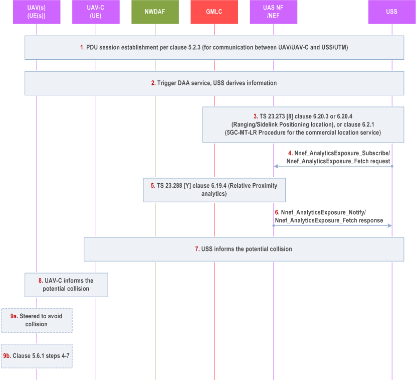
Step 1.
The UAV establishes a PDU Session for communication with the USS as described in clause 5.2.3.
Step 2.
The DAA service may be triggered by UAV(s). The UAV(s) (via its paired UAV-C) requests DAA service from USS. The request message includes identifier of the UAV(s) (e.g. GPSI(s), CAA-Level UAV ID(s)). USS derives information on DAA service and decides to subscribe/request to 5GC for GMLC service on Ranging/Sidelink Positioning location and/or Relative Proximity predictions on collision from NWDAF.
Step 3.
The USS may request GMLC service via NEF:
Step 4.
- The USS may request GMLC service via NEF for Ranging/Sidelink Positioning location results, i.e. the relative positioning between UAV UEs as described in clause 6.20.3 of TS 23.273 for one notification, or clause 6.20.4 of TS 23.273 for notifications (steps 1-20 for initiation monitoring, steps 21-31 for monitoring periodic).
- USS as AF may send the absolute positioning request to GMLC, including UAV UE1 ID (UE1 GPSI) and UAV UE2 ID (UE2 GPSI) as described in clauses 6.2 and 6.3.1. GMLC replies to USS of the absolute location of UAV 1 and UAV 2. USS calculates the relative positioning result based on the UAV UE1 absolute location and UAV UE2 absolute location.
The USS may request NWDAF service via NEF:
Step 4a.
The USS may subscribe or request notification on Relative Proximity predictions provided by NWDAF via NEF by invoking Nnef_AnalyticsExposure_Subscribe service operation as defined in clause 6.1.1.2 of TS 23.288 or Nnef_AnalyticsExposure_Fetch service operation as defined in clause 6.1.2.2 of TS 23.288. The subscribe/request message include identifier of the UAV(s) (e.g. GPSI(s)). The other parameters included in the request are described in clause 6.19 of TS 23.288.
Step 4b.
After NEF receives the request from the USS, the NEF interacts with the NWDAF as described in the procedure in clause 6.19.4 of TS 23.288. The NEF maps the parameters in the request from the USS to information used by the 3GPP system. The NWDAF interacts with GMLC for UE position. If the requested type of location is "current or last known location" and the requested maximum age of location information is available, the GMLC verifies whether it stored the previously obtained location estimate of the target UE. If the previously obtained location estimates of the target UE exist and meets the age of location requirement, the GMLC sends it to the NWDAF; if it does not exist, the GMLC sends provide positioning request to AMF to determine current location for the target UE and sends it to the NWDAF.
Step 4c.
If the NEF receives the response from the NWDAF, the NEF notifies the USS with the Relative Proximity predictions by invoking Nnef_AnalyticsExposure_Notify service operation for a Subscribe-Notify model as defined in clause 6.1.1.2 of TS 23.288 or Nnef_AnalyticsExposure_Fetch service operation for a Request-Response model as defined in clause 6.1.2.2 of TS 23.288.
Step 5.
If receiving the location of UAV1 and UAV2, USS calculates the relative positioning result for UAV UE1 location and UAV UE2 location from step 1 and step 2. The USS estimates the potential collision based on the information received in step 3 and/or the predictions from step 4c. The USS informs the UAV-C(s) the potential collision. The message may include collision alert, predicted time of collision, CAA-level UAV IDs of the paired UAVs which may collision (e.g. UAV 1 and UAV 2), deconflicting specific parameters (e.g. trajectory correction information to avoid collision).
USS may be replaced by TPAE.
Step 6.
The UAV-C(s) informs its paired UAV(s) the potential collision and information received from the USS, include collision alert, predicted time of collision, CAA-level UAV IDs of the paired UAVs which may collision, and deconflicting specific parameters (e.g. trajectory correction information to avoid collision).
Step 7.
UAVs performs operations to avoid collision.
Step 7a.
If both the two UAVs which may collision (e.g. UAV 1 and UAV 2) been informed by their paired UAV-C(s), the UAVs can be steered to avoid collision in accordance with the received information (e.g. trajectory correction information to avoid collision) and using mechanisms that are out of scope for 3GPP.
Step 7b.
If only one of the two UAVs which may collision (e.g. UAV 1) been informed by its paired UAV-C, the UAV 1 triggers conflict resolution procedure with UAV 2 as described in steps 4-7 in clause 5.6.1.
5.14.3 Procedure for AAM Triggered Network-assisted DAA p. 86
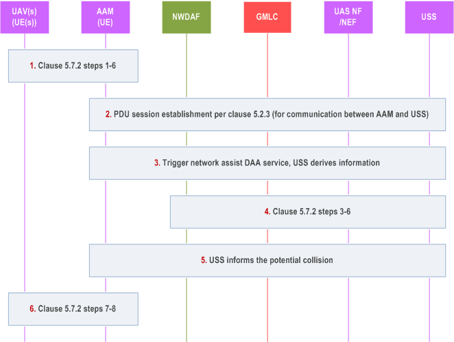
Step 1.
As described in clause 5.7.2 steps 1-6, the UAV(s) listens for signals on the correspondingly destination Layer-2 ID configured for the used service type. The AAM scans the airspace over the area/arena for UAV(s), retrieves for each detected UAV the corresponding Remote-ID and establishes a PC5 direct communication link with the discovered UAV. Using the PC5 unicast direct communication link the AAM and the UAV establishes a bidirectional communication channel for exchange of messages.
Step 2.
The AAM establishes a PDU Session for communication with the USS as described in clause 5.2.3.
Step 3.
The AAM may request network assist DAA service from USS. The request message includes identifier of the UAV(s) (e.g. GPSI(s), CAA-Level UAV ID(s)). USS derives information on DAA service and decides, e.g. to request GMLC service for Ranging/Sidelink Positioning location, to subscribe/request to NWDAF for Relative Proximity predictions on collision.
Step 4.
The USS requests GMLC service for Ranging/Sidelink Positioning location and/or subscribes/requests notification on Relative Proximity predictions provided by NWDAF via NEF, as described in steps 3-6 of clause 5.14.2.
Step 5.
The USS estimates the potential collision based on the received information/analytics in step 4. The USS informs the AAM the potential collision. The message may include collision alert, predicted time of collision, CAA-level UAV IDs of the paired UAVs which may collision (e.g. UAV 1 and UAV 2), deconflicting specific parameters (e.g. trajectory correction information to avoid collision).
Step 6.
The AAM provides the determined steering policy to the specific UAVs (e.g. UAV 1 and UAV 2) according to the information received in step 5 and the UAVs are steered to avoid collisions in accordance with received policy and using mechanisms that are out of scope for 3GPP, as described in clause 5.7.2 steps 7-8.
5.14.4 Procedure for USS Triggered Network-assisted DAA p. 87
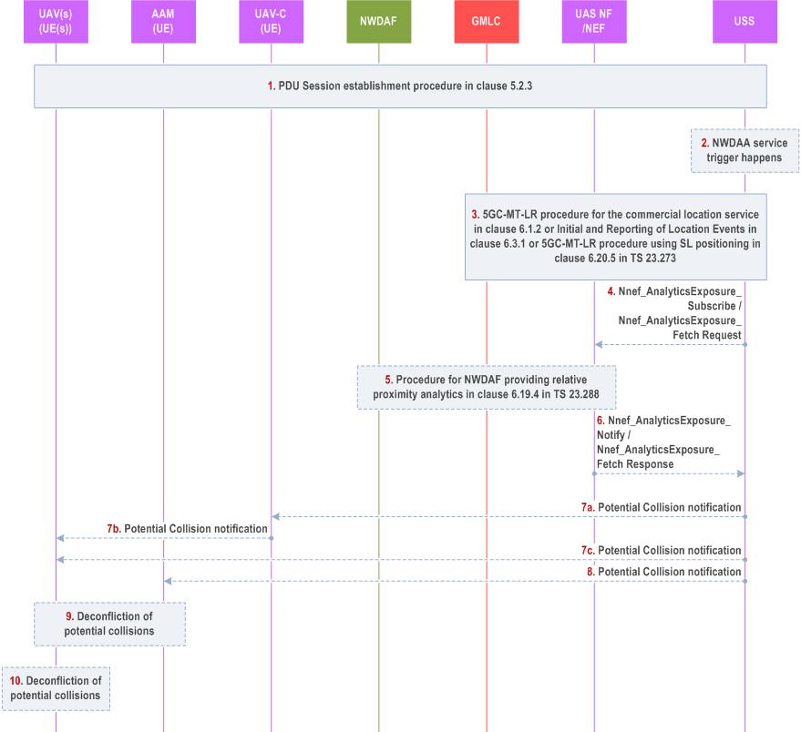
Step 1.
The UAV and UAV-C establish PDU Session for communication with the USS as described in clause 5.2.3.
Step 2.
The USS may decide to trigger NWDAA based on application layer request.
Step 3.
The USS requests absolute location of UAV(s) based on the identifiers received in step 2 by invoking the 5GC-MT-LR procedure for the commercial location service in clause 6.1.2 or Initial and Reporting of Location Events in clause 6.3.1 or 5GC-MT-LR procedure using SL positioning in clause 6.20.5 of TS 23.273.
Step 4.
[Optional] The USS may subscribe or request notification on Relative Proximity predictions provided by NWDAF via NEF by invoking Nnef_AnalyticsExposure_Subscribe service operation as defined in clause 6.1.1.2 of TS 23.288 or Nnef_AnalyticsExposure_Fetch service operation as defined in clause 6.1.2.2 of TS 23.288. The subscribe/request message include identifier of the UAV(s) (e.g. GPSI(s)).
Step 5.
[Optional] If the step 4 is performed, after NEF receive the request from the USS, the NEF interacts with the NWDAF as described in the procedure in clause 6.19.4 of TS 23.288. The NEF maps the parameters in the request from the USS to information used by the 3GPP system.
The NWDAF interacts with GMLC for UE position. If the requested type of location is "current or last known location" and the requested maximum age of location information is available, the GMLC verifies whether it stored the previously obtained location estimate of the target UE. If the previously obtained location estimates of the target UE exist and meets the age of location requirement, the GMLC sends it to the NWDAF; if it does not exist, the GMLC sends provide positioning request to AMF to determine current location for the target UE and sends it to the NWDAF.
Step 6.
[Optional] If the NEF receives the response from the NWDAF, the NEF notifies the USS with the Relative Proximity predictions by invoking Nnef_AnalyticsExposure_Notify service operation for a Subscribe-Notify model as defined in clause 6.1.1.2 of TS 23.288 or Nnef_AnalyticsExposure_Fetch service operation for a Request-Response model as defined in clause 6.1.2.2 of TS 23.288.
Step 7.
The USS performs step 7a and 7b or step 7C.
Step 7a.
If the USS detects the potential collision based on the information received in step 3 and/or step 6, the USS notifies the potential collision to UAV-C.
Step 7b.
[Conditional] If the step 7a is performed, the UAV-C further notifies the potential collision to UAV.
Step 7c.
If the USS detects the potential collision based on the information received in step 3 and/or step 6 is performed, the USS notifies the potential collision to UAV UE.
Step 8.
If the USS detects the potential collision based on the information received in step 3 and/or step 6, the USS notifies to potential collision to AAM.
Step 9.
[Conditional] If the step 8 is performed, to avoid confliction, steps 6-8 in high-level procedure for Ground-based DAA for an Area in clause 5.7.2 are performed.
Step 10.
[Conditional] If the step 7b or step 7c is performed, to avoid confliction, steps 4a-7 in DAA procedure based on PC5 in clause 5.6.1 are performed.
5.15 Support of No-Transmit Zones |R19| p. 88
The following principles are applied to support NTZ.
- NTZ enforcement applies to the UE that is a UAV UE (i.e. an aerial UE that is a UE with aerial subscription).
- NTZ enforcement by UAV UE applies for both LTE and NR.
- An NTZ can map to one or more cells or a fraction of one or more cells, or overlap different cells in a mobile operator network.
- Transmissions within the restricted frequency bands are not allowed from a UAV UE located in the NTZ, regardless of the service type.
- UAV UE shall neither transmit nor attempt to transmit in the NTZ.
- For UAV UEs outside of the NTZ, the normal EPS/5GS procedures apply.
- UAV UEs supporting NTZ regulations are configured/provisioned with NTZ assistance information, so that these UAV UEs are aware of the presence of NTZs.
- A list of the restricted frequency band(s) with Geographical Area (including coordinates with longitude, latitude and altitude restrictions) and optional time restriction.
- pre-configured;
- configured by using mechanism that is out of 3GPP scope.
- enforces NTZ based on the configured/provisioned NTZ assistance information.
- does not transmit any signalling or data within the restricted frequency bands upon applying NTZ enforcement.
- does not select/reselect any cells impacted entirely by an NTZ.
5.16 Altitude reporting for aerial UEs |R19| p. 89
5.16.1 General p. 89
In order to assist a USS/UTM with aerial UE's flight planning and monitoring, the 5GS may enable configuration of aerial UEs (UAVs) to perform altitude reporting. This may include providing aerial UEs with threshold values for altitude reporting and/or request reporting periodicity (e.g. threshold-based, event-based, periodic). For that, the 5GS may determine altitude thresholds and periodicity with which an aerial UE should report its altitude. Altitude thresholds can be derived, for instance, based on the flight path information provided by the serving USS/UTM during a pre-flight planning request or a USS changeover request. Delivery of the altitude thresholds and reporting periodicity can be done via application layer or via node-level signalling. The 5GS should forward the altitude measurements results to the AMF and NEF/UAS NF.
5.16.2 Instructing aerial UEs to perform altitude reporting p. 89
Procedure shown in Figure 5.16.2-1 specifies how the 5GS instructs the aerial UEs (UAVs) to perform altitude reporting, considering requests from a USS/UTM for assistance with UAV's flight. This procedure can be used in conjunction with the NEF-assisted pre-flight planning, in-flight monitoring and USS changeover as specified in clauses 5.12.2, 5.12.3 and 5.13, respectively.
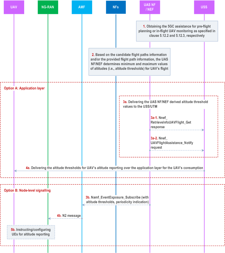
Step 1.
Option A: Application layer.
UAS NF/NEF assists the USS/UTM with pre-fligh planning, in-flight monitoring and/or USS changeover based on the received request, which is either a Nnef_RetrieveInfoUAVFlight_Get or a Nnef_UAVFlightAssistance_Create , as specified in clauses 5.12 or 5.13.
Step 2.
Based on the flight path information included in step 1 and other information obtained as a result of either of the procedures (i.e. NEF-assisted pre-flight planning specified in clause 5.12.2, NEF-assisted in-flight monitoring specified in clause 5.12.3, or USS changeover specified in clause 5.13.2), the UAS NF/NEF determines minimum and maximum values of altitudes (i.e. altitude range) for UAV's flight across each of the determined tracking areas (TAs) from the starting point to the destination point.
The determined minimum and maximum altitude values for each of the UAV UE is used by the UAS NF/NEF to derive altitude thresholds for altitude reporting events.
Additionally, the UAS NF/NEF determines whether to request the aerial UE to report its altitude information periodically, threshold-based (e.g. altitude becomes a higher/lower than the provided threshold, multiple threshold values can be provided) or event-based (e.g. change of a tracking area/NG-RAN node).
Step 3.
Delivering the UAS NF/NEF-derived altitude thresholds and, optionally, the indication about reporting periodicity (i.e. threshold-based, event-based, or periodic) for UE's altitude reporting to the aerial UE(s).
Step 3a.
Option B: Node-level signalling.
The UAS NF/NEF sends the derived altitude threshold values and provides indication about the required periodicity of the reporting (on demand, event-triggered, periodic, or per change of the altitude, or change of a specific geographical area) to the serving USS/UTM either in a Nnef_RetrieveInfoUAVFlight_Get response message or in a Nnef_UAVFlightAssistance_Notify message depending on the procedure that has triggered the UAS NF/NEF to derive the altitude thresholds for the aerial UE.
Step 4a.
The USS/UTM sends the altitude reporting thresholds and, optionally, indication about reporting periodicity (and any additional information required to perform the reporting, e.g. a list of TA(s)/NG-RAN node identifier(s) for event-based reporting, periodicity value for periodic reporting) to the UAV over the application layer for the UAV's consumption.
Step 3b.
The UAS NF/NEF may send an Namf_EventExposure_Subscribe request to the AMF to get notified about events of UAV's deviation from the assigned trajectory (i.e. Event ID = "Assigned Trajectory") as specified in clause 5.2.2.3.1 of TS 23.502. Inside the subscription request, the UAS NF/NEF may include the derived altitude thresholds and indication about reporting periodicity for the UE's altitude reporting.
Additionally, the UAS NF/NEF may also include an indication to perform UE's altitude reporting for all aerial UEs in a specific TA(s) or NG-RAN node(s).
Step 4b.
The AMF sends the corresponding N2 messages to all applicable NG-RAN node(s).
Step 5b.
The NG-RAN node(s) instructs the relevant UE(s) to perform altitude reporting as requested by the UAS NF/NEF (via AMF).
5.16.3 Reporting UE's altitude information p. 91
A procedure for reporting aerial UE's altitude information to the core network is shown in Figure 5.16.3-1. The reporting can be done by the aerial UE based on the received altitude reporting thresholds and indication about reporting periodicity as specified in clause 5.16.2.
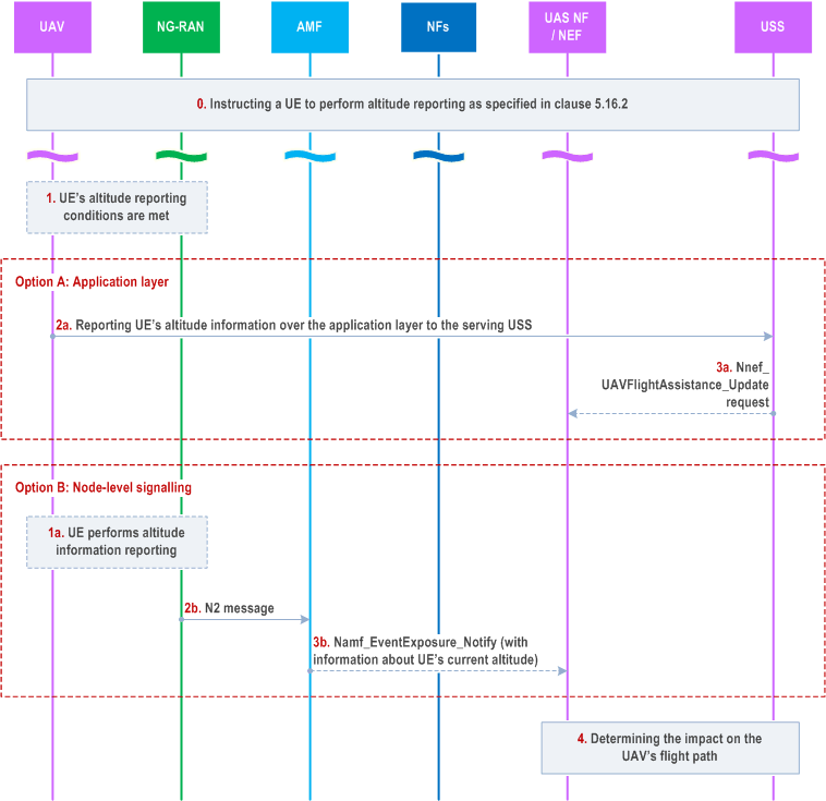
Step 0.
Option A: Application layer.
An aerial UE receives request to perform its altitude information reporting as specified in clause 5.16.2. The request may include altitude reporting thresholds and, optionally, indication about reporting periodicity.
Step 1.
UE's flight altitude meets the previously provided altitude reporting conditions (i.e. altitude thresholds and, optionally, reporting periodicity).
Step 2a.
Option B: Node-level signalling.
The UE may report the altitude information over the application layer to the serving USS/UTM in case the USS/UTM has provided altitude reporting threshold and, optionally, indication about reporting periodicity in step 4a in clause 5.16.2.
Step 3a.
The USS may invoke the Nnef_UAVFlightAssistance_Update to inform the UAS NF/NEF about UE's altitude.
Step 1a-2b.
The UE may provide a report with the altitude information to the NG-RAN. The report may contain the altitude information and, for instance, a time stamp or a report ID indicating when the UE has measured the altitude information that is being reported.
The NG-RAN node includes the received UE's altitude information in an N2 message to the AMF.
Step 3b.
The AMF provides the UAS NF/NEF the altitude information report inside a Namf_EventExposure_Notify request.
Step 4.
The UAS NF/NEF together with the USS determines the impact on UAV's flight path based on the received altitude information report; this aspect is outside the scope of the 3GPP.