Content for TS 23.256 Word version: 19.1.0
1…
4…
4.2…
4.2.3…
4.3…
4.4…
4.5…
5…
5.2.3…
5.2.4…
5.2.5…
5.2.5.3…
5.2.5.4…
5.2.7
5.2.8…
5.2.9…
5.3…
5.4…
5.5…
5.12…
5.13…
5.14…
6…
6.2…
6.3…
6.3.4…
A…
5.12 Pre-flight Planning and In-flight Monitoring for UAVs
5.12.1 General
5.12.2 Procedure for NEF Assisted Pre-flight Planning
5.12.3 Procedure for NEF Assisted In-flight Monitoring
...
...
5.12 Pre-flight Planning and In-flight Monitoring for UAVs |R19| p. 73
5.12.1 General p. 73
5G network may support pre-flight planning and in-flight monitoring for UAVs via the NEF service exposure. The USS/UTM may request assistance information to NEF of pre-flight planning and in-flight monitoring for UAV, after the UAV establishes user plane connection with the USS/UTM.
In the case of pre-flight planning, USS/UTM may request assistance information from the NEF for the following purposes:
- To determine the most suitable flight path among several candidate flight paths: USS/UTM provides multiple planned flight paths to the network and network leverages the network analytics, e.g. Movement Behaviour Analytics and/or QoS Sustainability Analytics, to determine the most suitable (in terms of the provided criteria, e.g. fastest, shortest) planned flight path among the provided candidates.
- To derive a flight path(s) for the requested starting and destination points for a UAV's flight: USS/UTM provides to the network information about the UAV's starting and destination points for the flight and the network leverages the network analytics e.g. Movement Behaviour Analytics and/or QoS Sustainability Analytics that can be exposed via NEF, to be used by the USS/UTM to determine a detailed flight path(s) for the UAV. NEF responds to the USS/UTM with the collected network analytics outputs to assist with the pre-flight planning.
- Output QoS information along the flight path: USS/UTM provides multiple planned flight paths to the network and network leverages QoS Sustainability Analytics to output QoS information for each of the provided flight paths.
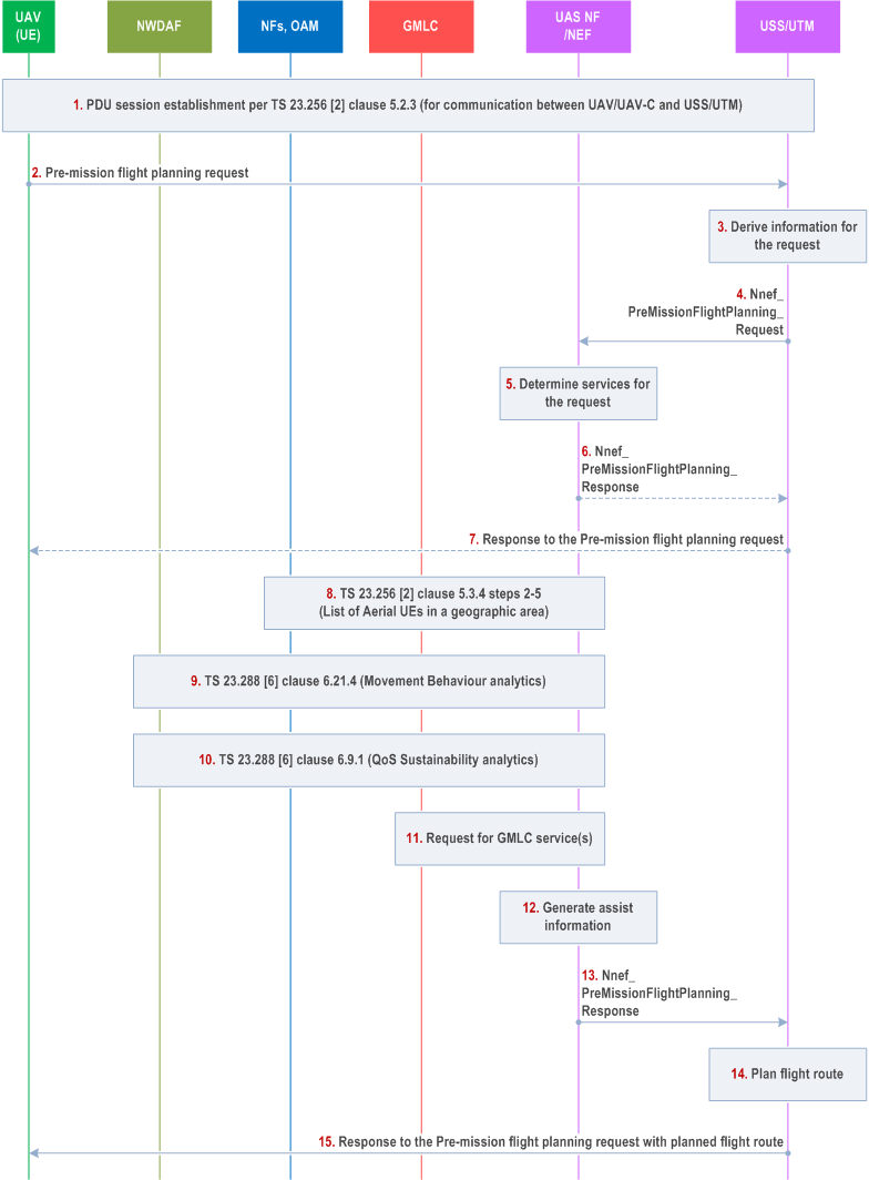
5.12.2 Procedure for NEF Assisted Pre-flight Planning p. 75

Step 1.
The UAV establishes a PDU Session for communication with the USS/UTM as described in clause 5.2.3.
Step 2.
(via application layer) The UAV requests the pre-flight planning service from the USS/UTM.
Step 3.
The USS/UTM determines to request a pre-flight assistance information from the 5GC and derives the information to provide to the NEF/UAS NF.
Step 4.
The USS/UTM sends an Nnef_RetrieveInfoUAVFlight_Get request with the indication to provide a pre-flight planning assistance for a target UAV (i.e. aerial UE). The request message includes identifier of the UAV (e.g. GPSI), information about the starting and ending points (and any intermediate point, if any) for the flight. The request may also include requirements on the flight path (e.g. on time, fastest, shortest), candidate flight path(s) (either received from the UAV or locally derived at the USS/UTM) and accuracy level of predictions relevant to the flight planning.
Step 5.
The NEF maps parameters included in the received Nnef_RetrieveInfoUAVFlight_Get request from the USS/UTM to information used by the 3GPP system (e.g. map the geographical area into an area of interest that is represented by a list of Cell IDs, gNB IDs or TAIs). The NEF determines services needed for the request and relevant NFs, e.g. NEF service on UAV tracking and mode (UAV location reporting mode, UAV presence monitoring mode, List of Aerial UEs in a geographic area), NWDAF analytics service (Movement Behaviour analytics and/or QoS Sustainability Analytics), GMLC service (e.g. Ranging/Sidelink Positioning location).
Step 6.
If the NEF cannot satisfy the requirements provided by the USS/UTM on flight planning (e.g. cannot get predictions relevant to the flight planning from NWDAF with the required accuracy level), the NEF rejects the pre-flight planning request from the USS/UTM and the NEF may include the details about the reasons of the rejection inside the response.
Step 7.
(via application layer) If the USS/UTM receives the response to the Nnef_RetrieveInfoUAVFlight_Get with the rejection of the pre-flight planning in step 6, the USS/UTM may respond to the UAV's pre-flight planning request and include the received details rejection reason(s) if available.
Step 8.
The NEF performs steps 2-5 of clause 5.3.4 to determine a list of UAVs in the areas of interest.
Step 9.
The NEF subscribes/requests for notification on Movement Behaviour analytics from NWDAF as defined in clause 6.21.4 of TS 23.288. The request includes an identifier of the UAV (e.g. GPSI) obtained in step 4 and height information of the UAV; other parameters included in the request are described in clause 6.21.4 of TS 23.288. Additionally, if the list of UAVs in the areas of interest is obtained in step 8, it may be used by the NEF to request Movement Behaviour analytics from NWDAF.
Step 10.
The NEF subscribes/requests for notification on QoS Sustainability analytics from NWDAF as defined in clause 6.9.1 of TS 23.288. The request includes an identifier of the UAV (e.g. GPSI) obtained in step 4 and the UAV's flight path information; other parameters included in the request are described in clause 6.9.1 of TS 23.288. Additionally, if the list of UAVs in the areas of interest is obtained in step 8, it may be used by the NEF to request QoS Sustainability analytics from NWDAF.
Step 11.
The NEF may request GMLC service(s), e.g. Ranging/Sidelink positioning location as defined in clause 6.20.4 of TS 23.273. The list of UAVs in the areas of interest output from step 8 may be used by the NEF to request the GLMC service on Ranging/Sidelink Positioning location.
Step 12.
The NEF generates the pre-flight assistance information based on the outputs from steps 8-10. The pre-flight assistance information may contain the best matching path(s) among the ones provided by the USS/UTM in step 4, or potential flight path information if candidate flight path(s) are not provided in step 4.
Step 13.
The NEF responds to the USS/UTM with the pre-flight assistance information.
Step 14.
The USS/UTM derives the flight path(s) using the retrieved pre-flight assistance information and flight planning mechanisms); these mechanisms are outside the scope of 3GPP.
Step 15.
(via application layer) The USS/UTM responds to the UAV with the planned flight path(s).
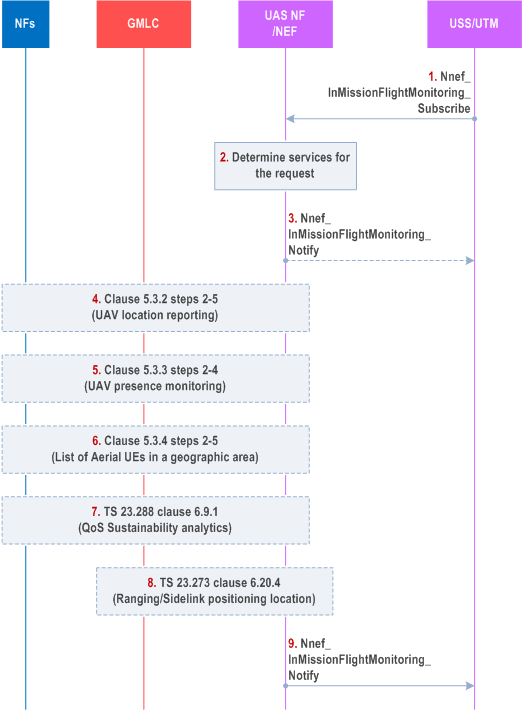
5.12.3 Procedure for NEF Assisted In-flight Monitoring p. 77

Step 1.
Steps 4-9 may be repeated for report monitoring results periodically.
The USS/UTM sends an Nnef_UAVFlightAssistance_Create request with an indication to provide the in-flight monitoring of a target UAV to NEF. The request includes an identifier of the UAV (e.g. GPSI) and information about the flight path(s), monitoring mode (e.g. UAV location monitoring, flight trajectory monitoring, flight environment monitoring, Ranging/Sidelink positioning location monitoring, QoS Sustainability analytics), report requirements (e.g. report format (event triggered or periodically), assistance information (e.g. the monitoring results, information generated from the monitoring results)). Additionally, the request may include the planned fight path(s) if the fight trajectory is set for the monitoring mode, a list of UAVs in the areas of interest if the flight environment is set for the monitoring mode, preset value for distance if the monitoring mode is set to Ranging/Sidelink positioning.
Step 2.
The NEF maps the parameters in the Nnef_UAVFlightAssistance_Create request from the USS/UTM to information used by the 3GPP system. The NEF determines services needed for the message and relevant NFs, e.g. NEF service on UAV tracking (UAV location reporting mode, UAV presence monitoring mode, List of Aerial UEs in a geographic area), GMLC service (Ranging/Sidelink Positioning location), NWDAF analytics service (QoS Sustainability Analytics).
Step 3.
If the NEF is not able to provide the requested information for in-flight monitoring, the NEF rejects the USS/UTM's request for the in-flight monitoring and the NEF may include in the Nnef_UAVFlightAssistance_Create response the details about the reason for rejecton, if available.
Step 4.
For UAV's location monitoring, the NEF executes steps 2-5 of clause 5.3.2 to obtain the location of the target UAVs.
Step 5.
For fight trajectory monitoring, the NEF executes steps 2-4 of clause 5.3.3. Upon to the request message in step 1 for reporting, the NEF may compare the monitored flight path with the planned fight path (if provided in step 1) and generates a report about whether the UAV is following the assigned path/trajectory.
Step 6.
For flight environment monitoring, the NEF executes steps 2-5 of clause 5.3.4 to obtain the information of aerial UEs presence in the same geographic area as the target UAV.
Step 7.
For QoS Sustainability analytics, the NEF requests the NWDAF service as described in clause 6.9.1 of TS 23.288. The subscribe/request message include an identifier of the UAV (e.g. GPSI) obtained in step 4 and the UAV's flight path information; other parameters included in the request are described in clause 6.9.1 of TS 23.288. The list of UAVs in the area of interest is obtained in step 8 and it may be used by the NEF to request the NWDAF on QoS Sustainability analytics.
Step 8.
For location monitoring via Ranging/Sidelink positioning service, the NEF requests the GLMC service for Ranging/Sidelink Positioning location results as described in clause 6.20.4 of TS 23.273, the procedure of SL-MT-LR for periodic, triggered Location Events (steps 1-20 for initiation of the monitoring, steps 21-31 for periodic monitoring). If the NEF does not have a list of UAVs in the area of interest, the NEF obtains the list of UAVs in the areas of interest in step 6 and use the obtained list as an input to request GLMC service for Ranging/Sidelink Positioning location.
Step 9.
The NEF notifies the USS/UTM using an Nnef_UAVFlightAssistance_Notify about the monitoring results (e.g. the location of the target UAV, indication on whether the UAV follows the flight path, the target UAV's presence in areas of interest, information about whether any other aerial UE/UAV is present in the same geographic area as the target UAV, distance to other UAVs and whether this distance is smaller than the preset value(s)).